


Yesterday, a wave of severe weather primarily impacted areas of Thessaly and northern Greece, and this disturbance is expected to continue today.
As per the latest weather report from the EMY, heavy rain and thunderstorms are anticipated in certain regions today (June 21, 2025), sometimes accompanied by high winds.
– In Halkidiki, Sporades, and Magnesia, from early morning until early afternoon.
– In Central Greece (particularly western and central areas) and the Peloponnese, from mid-morning to the afternoon.
Storm Cloud in Thessaly Producing Hail
According to Thodoros Kolydas, a storm cloud that formed in Thessaly yesterday reached a height of over 12 kilometers, resulting in hailstorms.
In extreme situations where the upward wind currents are strong and persistent, the tops of these storms can breach the stratosphere by several hundred meters, resulting in very cold cloud tops, as seen today (with an overshoot of 1.15°C).
“While hail of 2-3 cm in diameter is common in Greece nearly every year, on June 10, 2013, severe storms in Imathia and Pieria produced hailstones up to 8 cm in diameter, marking the largest hail documented in the last 30 years,” he noted.
“There’s also an archival report indicating that on June 15, 1956, in Loxada, Karditsa, 46 people were injured, and many livestock perished due to unprecedented hail, while in 1930 in Siatista, Kozani, hail the size of eggs resulted in the deaths of 22 individuals. This event occurred on the day of the Holy Spirit in Siatista,” he added.
Hail Damage in Thessaly
Yesterday, regions of Karditsa experienced rainfall, strong winds, and in certain areas, hail. In places like Petrino within the Palamas municipality, as well as parts of the Sofades municipality, hail caused significant crop damage, as reported by ERT.
Strong winds led to fallen trees in various locations, prompting the fire brigade to respond in three instances, particularly along the Karditsa-Trikala road and in the Agios Theodoros area. The Fire Department was also involved in interventions in the municipalities of Sofades, Karditsa, and Palamas, as stated by karditsalive.net.
Similar incidents, with strong winds causing tree falls, were reported in Trikala and Larissa. In Larissa city, strong winds caused several trees to fall. Awnings were torn down, and numerous pots were dislodged from balconies and windows, according to onunlarissa.gr.
Storm Activity in Fthiotida
A significant weather front passed through Fthiotida yesterday afternoon, causing localized disturbances, but no major issues were reported.
The intense weather began shortly after 17:00 and lasted approximately 35 minutes, with the most significant impact in the Domokos area and the northern section of the prefecture. Strong winds and electrical activity accompanied the storm, with frequent lightning observed.
Heavy rain, hail, and powerful winds affected villages in the plain, including Neo Monastery, Sofiada, Vardali, Agrapidia, Petrilia, and Thaumakos. Residents described it as a notably intense but brief weather event, causing considerable damage.
Initial assessments by farmers indicated severe destruction to crops, uprooted or broken trees, and substantial loss of production due to the sudden volume of water and hail.
This wave of bad weather also made its presence felt in eastern Fthiotida, with occurrences in Stylida, Raches, and Pelasgia, where tree falls were reported, but no damage was noted.
Hail in Mountainous Corinthia
A heavy hailstorm struck the village of Lavka Stymphalia in mountainous Corinthia on Friday afternoon, causing harm to vegetables and vines, according to korinthostv.gr.
Thunderstorms were reported on June 20, mainly affecting the continental regions, often accompanied by significant electrical activity.
The Lightning Imager instrument from the Meteosat-12 weather satellite recorded 18,924 electrical discharges over Greece within a 24-hour period until 21:40 GMT. These discharges included various types of lightning.
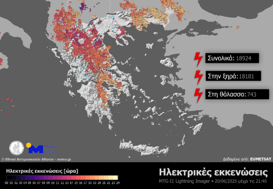
(Figure 1. Electrical discharges recorded over Greece from the Lightning Imager instrument of the Meteosat-12 weather satellite, from the start of the 24-hour period until 21:40 GMT)
Additionally, significant rainfall amounts were noted in the mainland, particularly in Central and Northern Greece, with Agii Theodoroi in Grevena receiving the highest precipitation of 93.8 mm by 22:00 GMT.
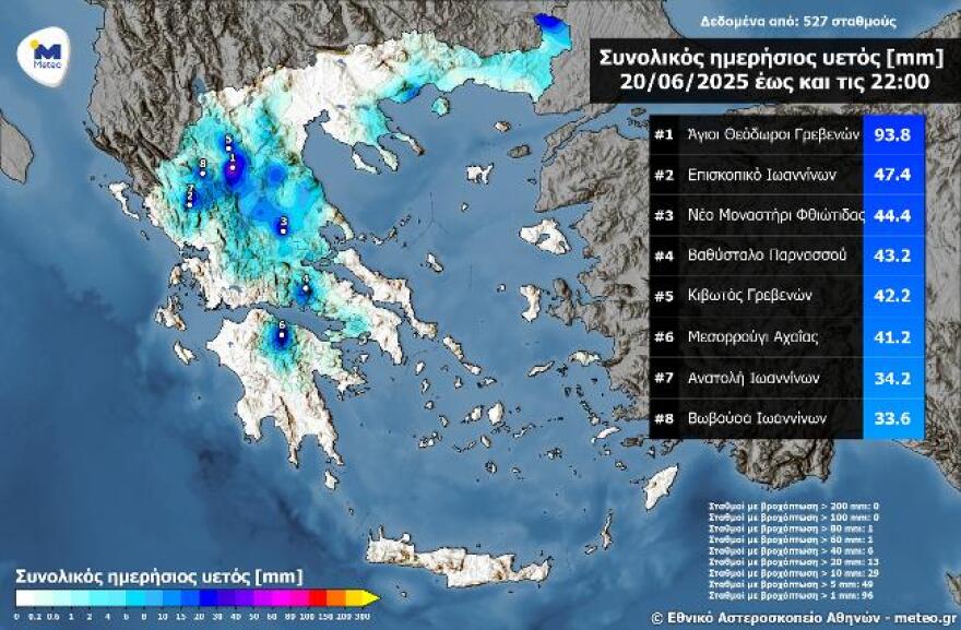
(Figure 2. Total daily precipitation recorded by the automatic weather stations of the National Observatory of Athens – meteo.gr network as of 22:00 GMT)
Today’s Weather
Today’s forecast calls for sunshine with some clouds, increasing over eastern regions and from noon in the rest of the mainland and Crete’s mountains. Local showers are expected in the morning in Eastern Thessaly (Magnesia), Sporades, Evia, Eastern Central Greece, and possibly in Central Macedonia (Halkidiki). In the afternoon and evening, local rain and thunderstorms may occur in the mountains of Epirus, Western and Central Greece, the Peloponnese, and potentially in Crete’s mountains, with some intense phenomena and hailstorms in the Peloponnese, tapering off by evening.
The temperature will range from 21 to 34 degrees in Northern Greece (15 to 28 degrees in Western Macedonia), 25 to 32 degrees in Central and Southern Greece (up to 34 degrees in Thessaly), 18 to 35 degrees in Western Greece, 22 to 32 degrees in the Cyclades and Crete, 22 to 34 degrees in the East Aegean islands, and 25 to 32 degrees in the Dodecanese.
Winds in the Aegean will be blowing moderately from the north at 4-5 Beaufort, while in the Ionian Sea winds will be light and later shift to northwestern directions at almost moderate levels of 4 Beaufort, and locally moderate 5 Beaufort in the Northern Ionian Sea.
In Attica, a few clouds will form in the morning with occasional rain possible in the northern parts of the prefecture. Temperatures are expected to range from 27 to 32 degrees Celsius, with the north and east being 3-4 degrees cooler. Winds will be light to moderately strong from the north at 3-4 Beaufort and moderate at 5 Beaufort in the east.
In Thessaloniki, expect sunshine with a few clouds. The temperature will range from 23 to 34 degrees Celsius, with winds in Thermaikos initially from the northwest at almost moderate levels of 4 Beaufort, which will soon weaken to light and variable.
Weather Forecast for Sunday, June 22
In central Macedonia and eastern Thessaly, expect partly cloudy skies with occasional rain, particularly from midday to afternoon. Generally, clear weather is predicted for the rest of the country, with only intermittent clouds developing on the mainland and the Ionian Sea during midday to afternoon hours, leading to local rain mainly in the western mountains and the Ionian Sea.
Winds in the west will shift from easterly to westerly (3 to 5 Beaufort), maintaining the same intensity through the afternoon. In the east, they will come from the north at 4 to 6 Beaufort, and up to 7 and locally 8 Beaufort in the Aegean Sea.
The temperature will experience a slight decline, primarily in the east, reaching 30 to 31 degrees Celsius on the mainland and the Ionian Sea, and 26 to 28 degrees Celsius at sea.
Ask Me Anything
Explore related questions


