


Meteorologists are alerting the public to a significant weather system impacting parts of Greece, bringing rain, thunderstorms, and hail. The most severe conditions are expected today and tomorrow, driven by a cold air mass from the Balkan region. Citizens are advised to exercise caution due to the potential for dangerous local phenomena.
Key Weather Updates
Strong thunderstorms with lightning and hail are forecasted from today into the coming days, gradually diminishing by Sunday, June 2. Following this period, a shift towards summer weather with rising temperatures is expected for early next week.
Affected Areas
This weather instability will primarily affect:
- Mainland Greece, especially in central and northern regions
- Eastern and southern coastal areas, particularly from Friday to Saturday
- Island groups including Crete, Cyclades, and Dodecanese
Forecast Summary
Expert meteorologist Klearhos Marousakis notes that the cold air mass from the northwestern Balkans will trigger intense thunderstorms across various mainland locations, increasing lightning activity, heavy rainfall, and hail. Over the weekend, this instability will shift to eastern and southern maritime areas before gradually calming down by Sunday.
Marousakis advises caution: “We must remain vigilant, as these phenomena may be intense and potentially dangerous. Our forecast maps indicate a reduction in activity from early next week, giving way to summer heatwaves.”
In a more optimistic perspective, Giorgos Tsatrafyllias describes upcoming spring showers with afternoon rain and evening dew, suggesting that “the weather is transitioning to a warm, pleasant climate with no severe storms on the horizon.”
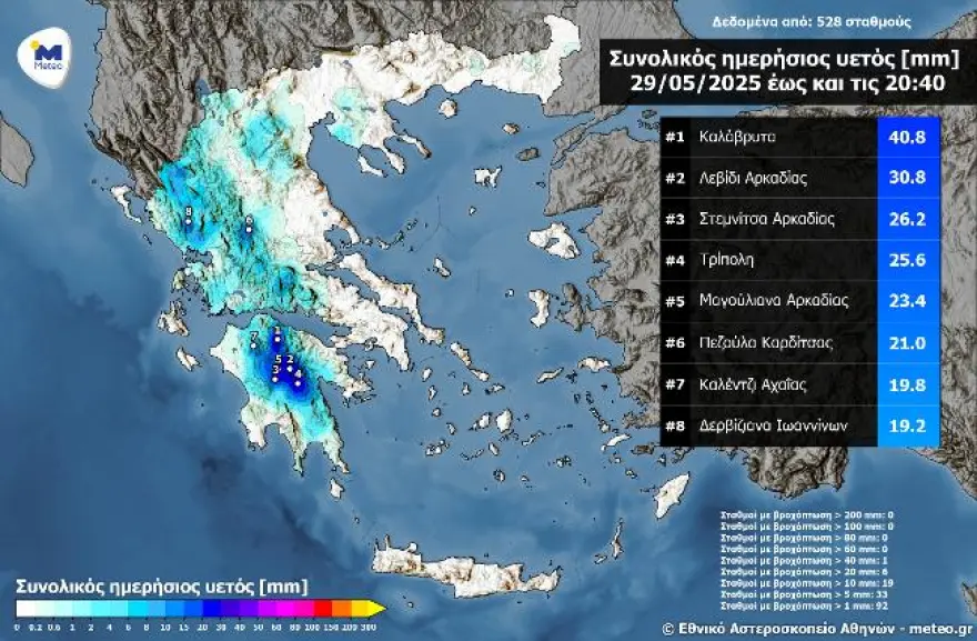
Recent Rainfall Highlights
Kalavryta recorded the highest rainfall yesterday, measuring 40.8 mm by 20:40, followed by Levidi and Stemnitsa in Arcadia. These figures highlight the ongoing wet conditions, especially across mainland Greece, as monitored by the National Observatory of Athens and its network of automated meteorological stations.
Today’s Weather Outlook
- Precipitation: Showers and thunderstorms are expected nationwide, with particularly heavy storms in Crete this afternoon. Activity will gradually decrease after peak hours.
- Temperatures: In Western Macedonia, temperatures will range from 11°C to 21°C. Across the rest of the country, values will range from 12°C in Sterea and Peloponnese to a high of 28°C in Epirus, while coastal areas will see highs around 24-27°C.
- Winds: Northerly winds in the Aegean will blow at 3-5 Beaufort, occasionally reaching 6 Beaufort during the afternoon in the Ionian Sea.
- Regional Highlights: Attica will experience clouds with localized rain, and temperatures will range between 18°C and 26°C. Thessaloniki will have similar conditions, expecting temperatures between 18°C and 27°C with intermittent rain or thunderstorms.
Weekend Forecast
Saturday (May 31): Expect partly cloudy skies with increasing clouds over mainland areas in the afternoon, leading to local rain and isolated thunderstorms, particularly in the mountains. Crete and the southern islands may see intense thunderstorms in the morning. Winds will predominantly come from the north at 3-7 Beaufort, with the strongest gusts in the Aegean.
Sunday (June 1): Cloud cover will continue over Crete with isolated thunderstorms. Elsewhere, the weather will gradually improve, with only localized showers expected in central and southern Greece. Temperatures will remain steady, with slight increases anticipated on Monday.
Next Week Outlook
Monday (June 2): Expect generally clear conditions, with some midday clouds and isolated rain in the mountains. Temperatures will rise slightly, signaling the onset of summer.
Tuesday (June 3): Fair weather will continue, featuring minimal cloud cover and a further slight increase in temperatures, with a few local mountain showers possible.
Greece is currently experiencing a brief but intense weather disturbance marked by thunderstorms, hail, and heavy rainfall, especially on the mainland and southern islands. Although conditions will improve by early next week, residents are advised to remain vigilant during peak instability hours. The upcoming days promise a transition from stormy weather to warmer, more stable summer conditions with rising temperatures.
Ask me anything
Discover related questions


