


In the upcoming days, Greece is set to experience summer-like temperatures. However, cloud cover will remain, accompanied by sporadic local showers — including mud rain — due to moderate levels of African dust affecting central and southern parts of the country.
Meteorologist Giorgos Tsatrafyllias notes that warm air masses will start moving in from the African coast today, bringing along Saharan dust. This phenomenon is expected to peak over the weekend, with temperatures soaring above 33°C.
Message from Tsatrafyllias:
“A new surge of African heat and dust will peak this weekend with temperatures reaching 33–34°C!
Starting tomorrow, warm air masses from the African coast will be accompanied by Saharan dust. South winds will prevail, not exceeding 5–6 Beaufort.
- This heatwave is expected to peak over the weekend, with temperatures in Thessaly, eastern Central Greece, the Peloponnese, Crete, and the Dodecanese exceeding 33°C, while Attica will see temperatures around 30–31°C.
- Dust levels will increase from Thursday, mainly impacting the Ionian Islands, the Peloponnese, Central Greece (including Attica), Thessaly, and Crete.
- On Wednesday and Thursday, instability is likely to develop in northern Greece, particularly in mountainous areas during midday and afternoon hours.”
High Pollen Levels Expected
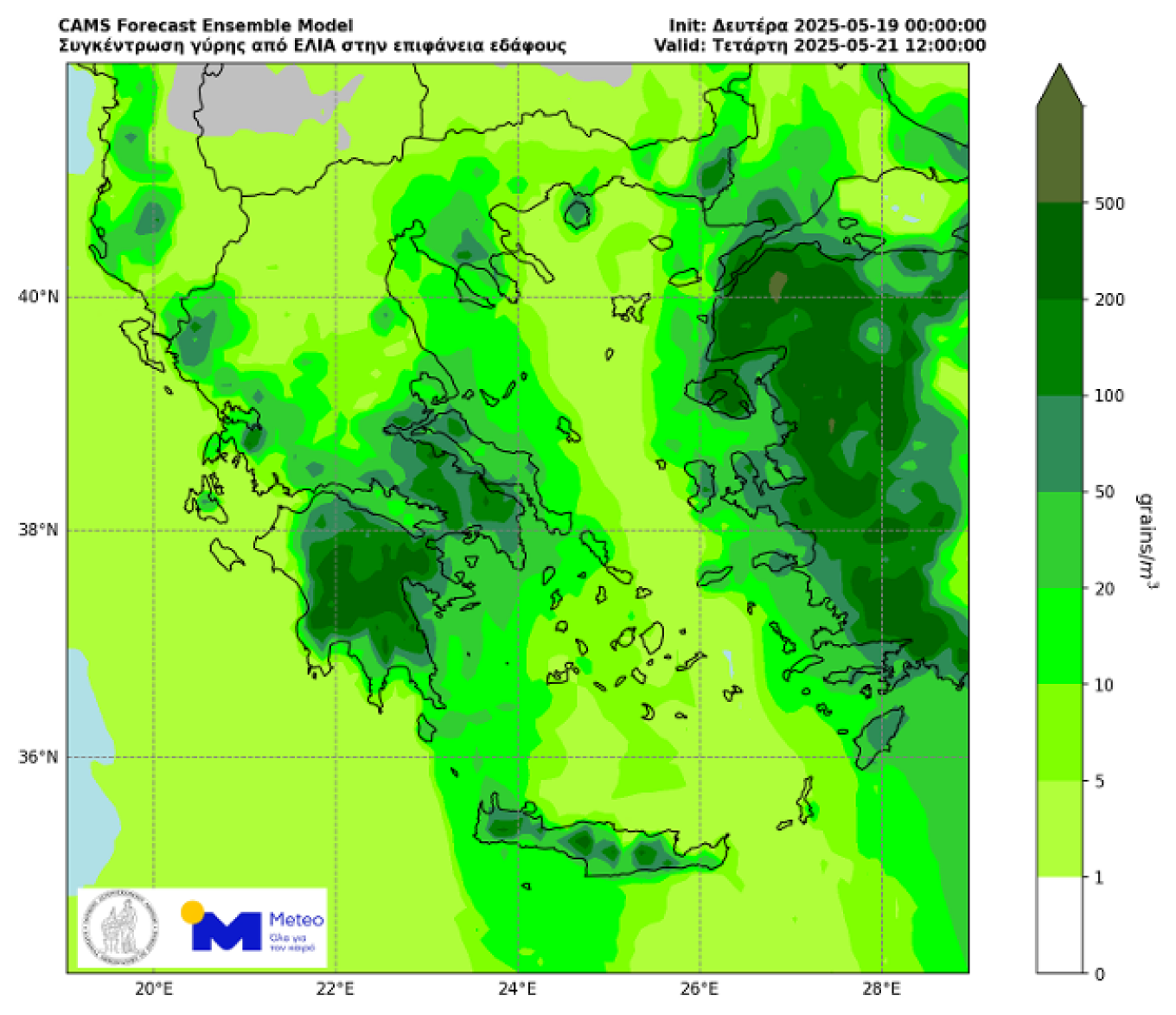
The peak period for atmospheric pollen levels is currently upon us in Greece, according to recent data from the European Copernicus Atmosphere Monitoring Service (CAMS).
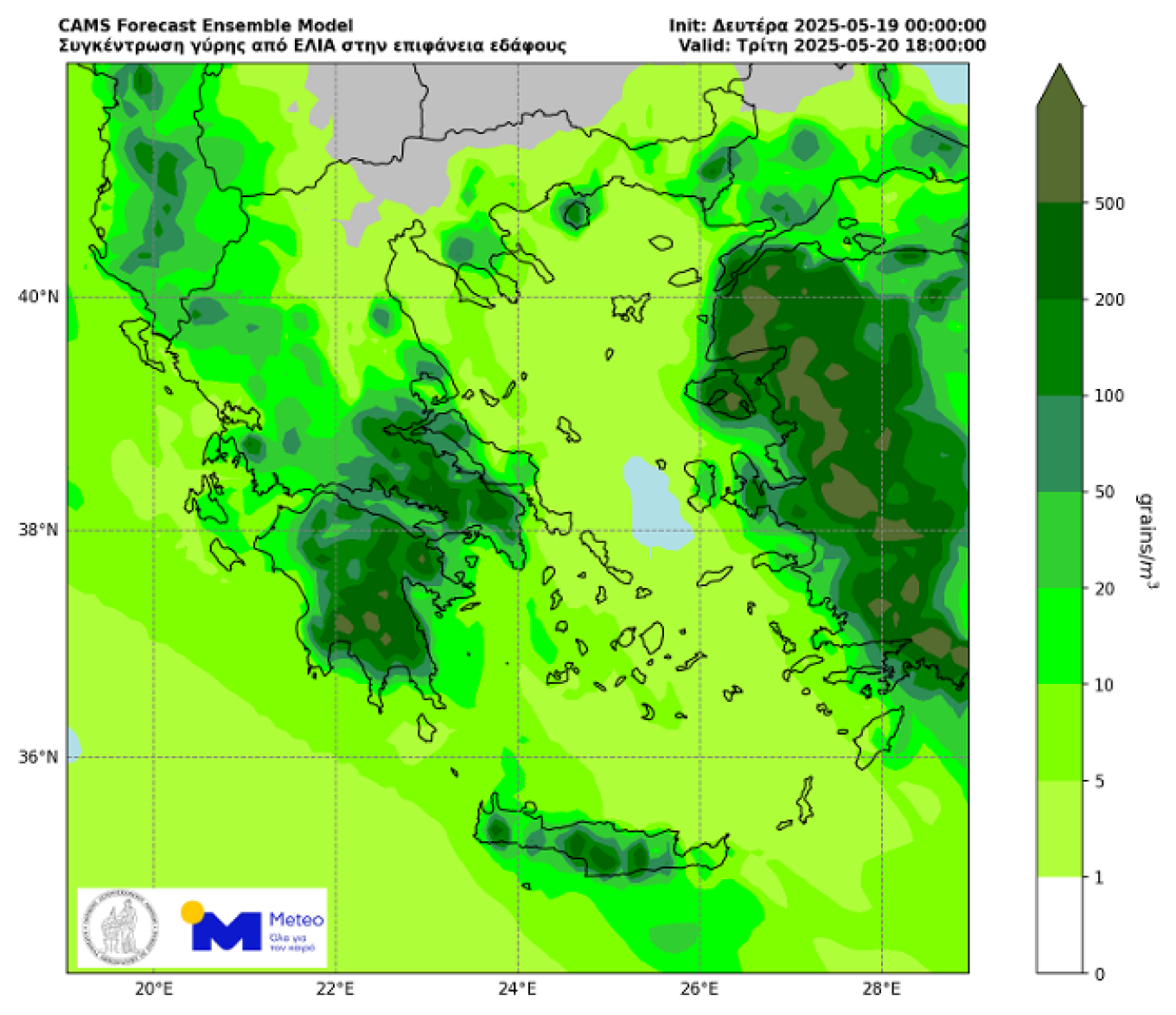
Maps from the METEO unit of the National Observatory of Athens display anticipated surface-level concentrations of olive tree pollen (Maps 1 & 2) and grass pollen (Maps 3 & 4) for Tuesday, May 20 and Wednesday, May 21, during midday and afternoon hours.

Weather Today
Overall, expect mostly clear skies, with some cloudiness in central and northern mainland Greece and the Ionian, where local showers and thunderstorms could develop over mountainous regions during the afternoon and evening.
Temperatures:
- Western Macedonia: 11–23°C
- Rest of Macedonia & Thrace: 12–29°C
- Ionian Islands: 14–25°C
- Epirus: 14–29°C
- Thessaly: 16–30°C
- Central Greece & Evia: 13–31°C
- Peloponnese: 14–29°C
- Aegean Islands: 12–27°C
- Dodecanese: 17–27°C
- Crete: 13–29°C
Winds: Southerly at 3–5 Beaufort; in the southeastern Aegean, northwesterlies at 4–6 Beaufort.
Attica: Generally clear with occasional clouds. Winds will shift from the northwest to southerly at 2–4 Beaufort. Temperatures will range from 17–29°C.
Thessaloniki: Expect periods of cloudiness with local showers and possible isolated thunderstorms over mountainous areas in the afternoon. Light variable winds. Temperatures will range from 13–25°C.
Thursday (May 22) Outlook
Expect partly cloudy skies, with denser cloud cover in some areas, leading to sporadic local showers or isolated storms in the Ionian in the morning and over mountainous mainland areas during the afternoon. Conditions will improve by evening.
Winds:
- South: Westerly at 4–6 Beaufort
- Elsewhere: South-southwesterly at 3–5 Beaufort
Temperatures: Minimal changes anticipated.
Friday (May 23) Outlook
Fair weather is expected, with some clouds developing in northern regions during the afternoon, potentially leading to local showers in the mountains. Visibility may be reduced in western areas during early morning hours.
Winds: West-southwesterly at 3–4 Beaufort, increasing to 5–6 in southern areas.
Temperatures: Slight increase expected.
Saturday (May 24) Outlook
Partly cloudy skies are expected in central and northern Greece, with local showers or isolated afternoon thunderstorms over mountainous areas. The south will mostly experience clear skies, though weather conditions will favor the transport of African dust.
Winds: Southerly at 3–5 Beaufort, reaching up to 6 in western seas.
Temperatures: Slight further increase in the south.
Sunday (May 25) Outlook
Initially fair weather is expected. However, from midday onward, unstable weather is likely to develop in the south, gradually spreading across the country, bringing showers and sporadic thunderstorms in western and northern areas.
Winds: Southerly at 3–5 Beaufort, increasing to 6–7 Beaufort in western and southern seas.
Temperatures: A slight rise is expected in central and particularly southern Greece.
Ask me anything
Explore related questions


