• Latest
Turkey submits its own Maritime Spatial Planning map to UNESCO – Effectively dividing the Aegean sea in two

Turkey submits its own Maritime Spatial Planning map to UNESCO – Effectively dividing the Aegean sea in two

June 16, 2025
Οι παραχωρήσεις απογειώνουν τη ΓΕΚ ΤΕΡΝΑ

Έφθασε το «20άρικο» η ΓΕΚ ΤΕΡΝΑ

June 17, 2025
Τα αντανακλαστικά των αγορών

Τα αντανακλαστικά των αγορών

June 17, 2025
«Προκαταβολή» μερισμάτων 4 δισ. ευρώ

Οι πύραυλοι στη Λεωφόρο Αθηνών, η μεζούρα του Ερντογάν και ένα στοίχημα που μπορεί να πάει πολύ στραβά

June 17, 2025
Ποιοι γιορτάζουν σήμερα 9 Μαΐου

Ποιοι γιορτάζουν σήμερα 17 Ιουνίου

June 17, 2025
Το Ιράν να διαπραγματευτεί «προτού να είναι πολύ αργά»

Στη ζούγκλα

June 17, 2025
Παγώνει «χαμόγελο του δολαρίου» -Κίνδυνος, να ξεφορτωθούν οι Ασιάτες δολάρια ύψους 2,5 τρισ. δολαρίων

Πλήγμα στο δολαριακό καταφύγιο

June 17, 2025
«Το Ιράν είναι κύρια πηγή περιφερειακής αστάθειας»

«Το Ιράν είναι κύρια πηγή περιφερειακής αστάθειας»

June 17, 2025
Axios: Συνομιλίες ΗΠΑ – Ιράν αυτή την εβδομάδα για πυρηνική συμφωνία και εκεχειρία με το Ισραήλ

Axios: Συνομιλίες ΗΠΑ – Ιράν αυτή την εβδομάδα για πυρηνική συμφωνία και εκεχειρία με το Ισραήλ

June 17, 2025
Avax: Σε 3 άξονες η νέα στρατηγική

Χρηματιστήριο: Πόσες ίδιες μετοχές κατέχει ο AVAX

June 17, 2025
Το μεγάλο rebound μετά το «κραχ των δασμών», τα παράδοξα και τι αποκαλύπτει η ιστορία 100 ετών

Ο πλανήτης σε συναγερμό, οι αγορές τον χαβά τους: Γιατί δεν συγκινούνται ούτε από τον πόλεμο Ισραήλ

June 17, 2025
Δεν υπάρχουν άλλες ζημιές στις εγκαταστάσεις εμπλουτισμού του Ιράν από τα ισραηλινά πλήγματα

Ο Τραμπ εξετάζει το ενδεχόμενο να βομβαρδίσει πυρηνικό εργοστάσιο του Ιράν

June 17, 2025
Έγινε «100άρα» η AVE με χείρα βοηθείας από… Bazaar

Έγινε «100άρα» η AVE με χείρα βοηθείας από… Bazaar

June 17, 2025
NeaGreece
Advertisement
  • Αρχική
  • ΕΛΛΑΔΑ
  • Διεθνή
  • πολιτική
  • Κοινωνία
  • αθλητισμός
  • Lifestyle
No Result
View All Result
  • Αρχική
  • ΕΛΛΑΔΑ
  • Διεθνή
  • πολιτική
  • Κοινωνία
  • αθλητισμός
  • Lifestyle
No Result
View All Result
NeaGreece
No Result
View All Result
Home AEGEAN

Turkey submits its own Maritime Spatial Planning map to UNESCO – Effectively dividing the Aegean sea in two

info@neagreece.gr by [email protected]
June 16, 2025
in AEGEAN, aegean sea, Maritime Spatial Planning, turkey, UNESCO, World
0
Turkey submits its own Maritime Spatial Planning map to UNESCO – Effectively dividing the Aegean sea in two
0
SHARES
0
VIEWS
Share on FacebookShare on Twitter

Turkey is asserting its position by submitting its own maritime maps to the appropriate UNESCO agency in response to Greece’s recent completion of the first phase of its maritime spatial planning. This marks Greece’s first official step toward organizing human activities in the marine environment—an initiative Athens plans to present to the United Nations soon.

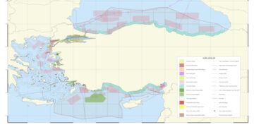
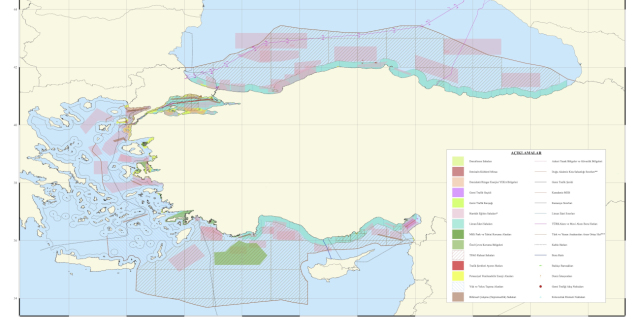
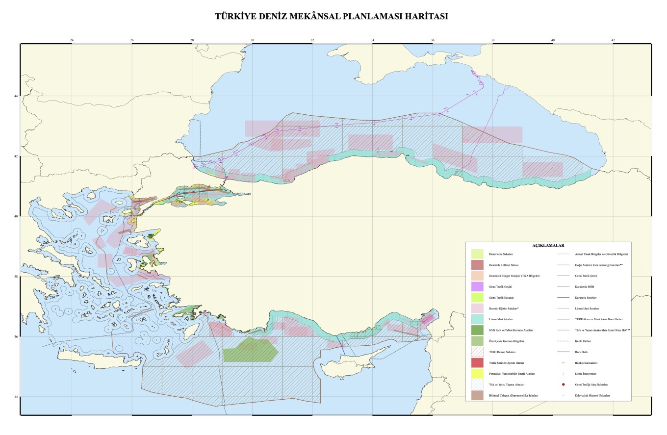
The Turkish maps embody Ankara’s well-documented revisionist approach, which contests the legal status of the Greek islands and supports its “median line” theory between Turkey and mainland Greece. The notable red line on the map begins at the Evros River’s mouth and stretches across the northern and southern Dodecanese, disregarding the continental shelf of the islands and acknowledging only their 6-nautical-mile territorial seas.

Overview of the Turkish Map

Created by Ankara University, the map was officially presented to UNESCO as a “scientific” document. In its southeastern section, which covers the Eastern Mediterranean, diagonal lines indicate offshore blocks designated for exploration by the Turkish Petroleum Corporation (TPAO). These areas coincide with Greece’s maritime claims and are connected to the “Blue Homeland” doctrine.

Additionally, Ankara unilaterally marked permanent military training zones in pink.

A significant feature is a black line that traverses international waters north of Crete and continues to the Dardanelles, referred to as a “cable” on the Turkish maps, although its purpose and specifics remain unexplained.

View the Map:

Response to Greece’s Initiative

Greece’s introduction of its maritime spatial planning project has provoked strong reactions from Turkey. For the first time, Greece has delineated the geographical boundaries for its activities in the marine environment—a development firmly rooted in European and international law, representing a significant assertion of national sovereignty.

View the Greek Map:

Ask Me Anything

Explore Related Questions


Tags: AEGEANdividingeffectivelymapMaritimePlanningSeaSpatialSubmitsTurkeyUNESCO
Previous Post

Τα 5 διακριτικά σημάδια που μπορούν να προβλέψουν με 100% βεβαιότητα αν ένας γάμος θα αντέξει

Next Post

Άγρια σύγκρουση Λεωνίδα και Αλέξη

info@neagreece.gr

[email protected]

Next Post
Άγρια σύγκρουση Λεωνίδα και Αλέξη

Άγρια σύγκρουση Λεωνίδα και Αλέξη

NeaGreece.gr

© 2025 NeaGreece.gr.

Navigate Site

  • About
  • Advertise
  • Privacy & Policy
  • Contact

Follow Us

No Result
View All Result

© 2025 NeaGreece.gr.