


Expect summer-like weather over the Holy Spirit long weekend, with mostly clear skies nationwide and temperatures soaring up to 37°C in some regions. This warm spell is expected to persist until at least Monday, though meteorologists emphasize it is not classified as a heatwave.
Meteorologist Thodoris Kolydas noted that elevated temperatures will continue through Monday but warned of unstable weather conditions in the northern areas.
ΖΕΣΤΗ ΚΑΙ ΑΣΤΑΘΕΙΑ – ΥΨΗΛΕΣ ΘΕΡΜΟΚΡΑΣΙΕΣ ΜΕΧΡΙ ΚΑΙ ΤΗ ΔΕΥΤΕΡΑ ΤΟΥ ΑΓΙΟΥ ΠΝΕΥΜΑΤΟΣ
✅Αρκετή ζέστη σήμερα στα ηπειρωτικά με τον υδράργυρο τοπικά να φτάνει τους 36 βαθμούς Κελσίου, ενώ παράλληλα εκδηλώθηκε και αστάθεια στα βόρεια.
✅Η θερμοκρασία το Σάββατο θα ανέβει κι άλλο και… pic.twitter.com/hUM0r542TV— Theodoros Kolydas (@KolydasT) June 5, 2025
“On Saturday, temperatures are expected to reach 36–37°C. The hottest days will be Sunday and Whit Monday, followed by a drop back to normal summer temperatures starting Tuesday,” he stated.
However, those traveling north should pack an umbrella, as meteorologist Klearchos Marousakis warned that warm weather might bring unexpected conditions.
“A colder air mass moving into our area may trigger severe thunderstorms in the northern regions during the afternoon and early evening,” he mentioned in a social media post.
Regions with Highest Temperatures on Thursday:
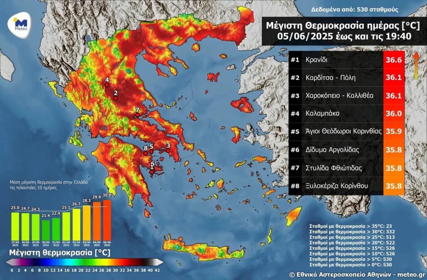
According to meteo.gr, four areas reported temperatures exceeding 36°C:
- Kranidi – 36.6°C
- Karditsa (City) – 36.1°C
- Harokopio, Kallithea – 36.1°C
- Kalabaka – 36.0°C
- Agioi Theodoroi, Corinthia – 35.9°C
- Didyma, Argolida – 35.8°C
- Stylida, Fthiotida – 35.8°C
- Xylokeriza, Corinth – 35.8°C
Early June 2025: Warmer Greek Seas
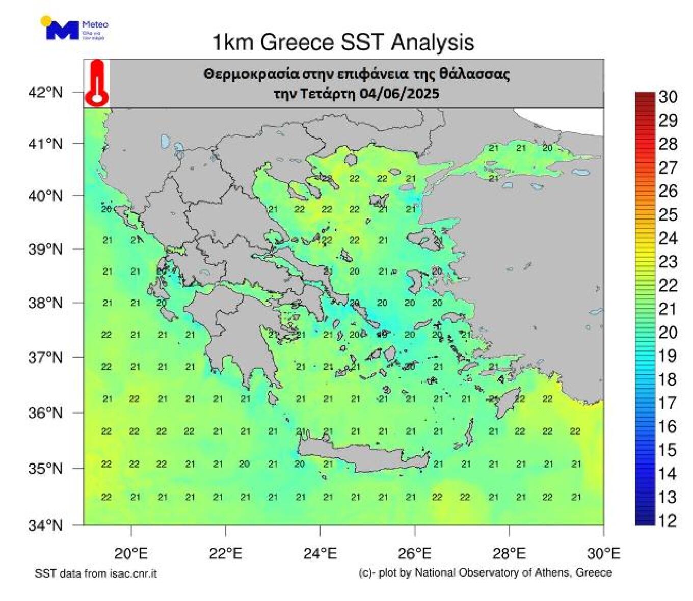
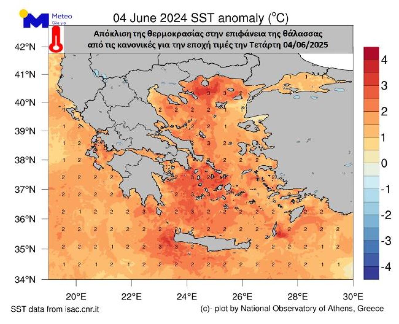
The warm air temperatures in early June 2025, coupled with minimal wind, have resulted in rising sea surface temperatures. Satellite data from meteo.gr reveals the following patterns:
- Surface water temperatures range from 20–22°C
- The Ionian Sea is approximately 2°C warmer than average for this time of year
- The Aegean Sea is 2–3°C above seasonal averages
Today’s Weather Forecast
Clear skies are anticipated across the country, with some local clouds developing. In the afternoon, cloud cover will increase over the mainland, particularly in Central and Northern Greece, with possible showers and thunderstorms, especially in mountainous regions where they may intensify.
Temperature Ranges:
- Western Macedonia: 13–29°C
- Rest of Macedonia and Thrace: 16–33/35°C
- Thessaly: 16–34/36°C
- Western Greece: 17–31/32°C
- Remaining mainland: 18–34/36°C
- Ionian Islands: 16–31/32°C
- Aegean Islands and Crete: 17–31/33°C
- Eastern Aegean Islands: up to 35–36°C
Wind Conditions:
- Aegean: NW winds at 4–5 Beaufort, with westerly winds in the southern regions
- Ionian: WNW winds at 3–4 Beaufort
- Corinthian Gulf: W winds at 3–5 Beaufort
Athens:
Sunny with some clouds in the afternoon. Winds from the north at 2–4 Beaufort. Temperatures will range from 22–34/35°C.
Thessaloniki:
Partially cloudy with a chance of showers or thunderstorms in the mountains during warmer hours. Winds variable at 2–3 Beaufort. Temperatures expected to be between 23–32°C.
Ask Me Anything
Explore Related Questions


