


Today’s weather features rain and storms continuing into the early morning, strong northern winds, and a drop in temperatures. Meteorological reports indicate that a weather change, initiated yesterday afternoon, has notably reduced the African dust lingering in the atmosphere, with conditions expected to improve by midday in most regions.
However, the severe weather that impacted the country yesterday caused numerous issues in Crete, Lamia, and Attica.
Heavy rainfall late Sunday night rendered Koropi Avenue in Markopoulo impassable, stranding numerous vehicles and prompting many drivers to contact the Fire Department.
By midnight, persistent rainfall led to flooding in several regions, with the fire department receiving at least 17 requests for water removal in northeastern Attica, particularly in Marathon, Rafina, Pikermi, and Penteli.
According to Meteo, rainfall was recorded in late Sunday in Agia Paraskevi, Pallini, Papagou, Marousi, Kantza, Vyronas, Spata, Nea Makri, Penteli, Rafina, Koropi, Gerakas, and Markopoulo.
Rain was also noted in Naxos, Skyros, Ikaria, parts of Evia, Boeotia, Chalkidiki, Thasos, Drama, and Alexandroupolis.
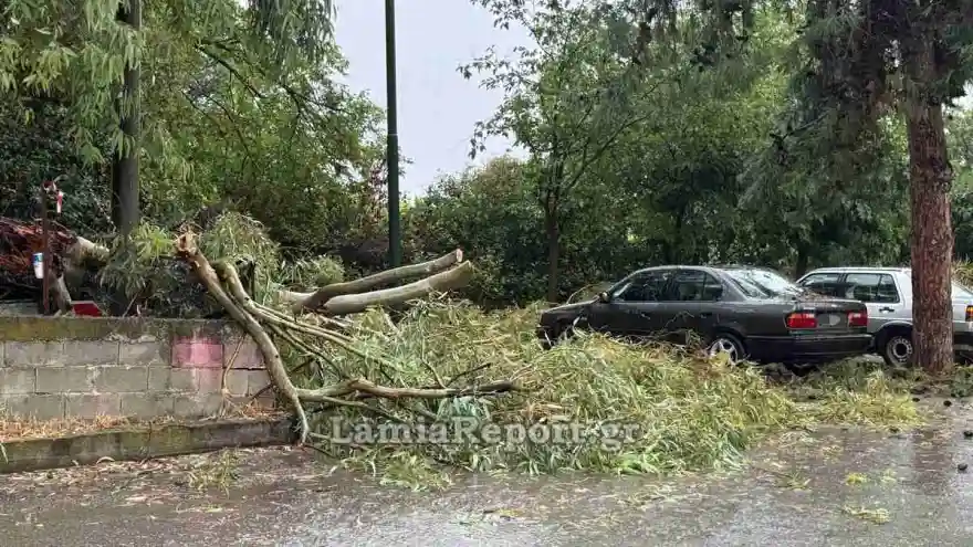
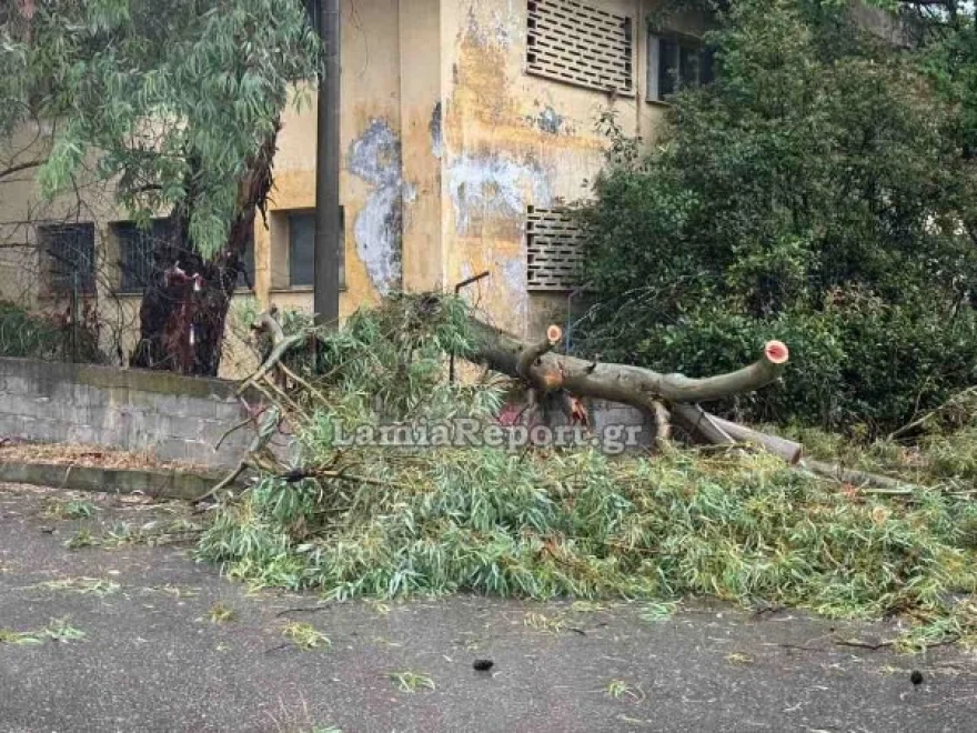
Lamia experienced intense rainfall, leading to numerous trees being uprooted by strong winds, and causing power outages in the southern area, leaving hundreds of residents without electricity for over two hours.
The fire department received multiple requests for water removal, particularly from southern neighborhoods, while the Traffic Police restricted access to dangerously overflowing streams that were impassable for both vehicles and pedestrians.

Issues in Crete
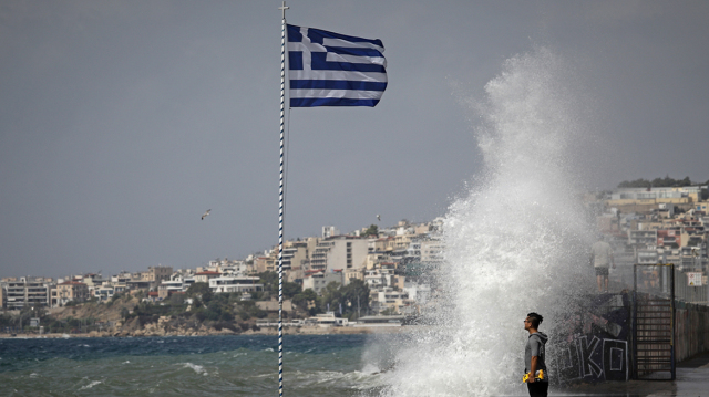
In Crete, strong southern winds caused extensive damage, knocking down trees, utility poles, and even a football goalpost. These winds also disrupted flights at Heraklion and Chania airports, affecting passengers.
Kissamos Municipal Stadium was not spared; the coastal Kastelli stadium suffered damage, including a collapsed goalpost and a high jump mat that was blown away over considerable distances.

More than ten aircraft were unable to land at Heraklion Airport on Sunday. In Chania, a flight diverted from Frankfurt to Athens faced a four-hour delay before arriving. Other flights also experienced significant delays.
Rainfall Overview
Heavy rain and storms were reported in Central Greece, northeastern Peloponnese, Thessaly, Evia, Central and Eastern Macedonia, with later impacts seen in the Sporades, Thrace, the northern Aegean, and gradually in the eastern Aegean.
Thunderstorms and Lightning Activity
Meteo reported a significant electrical storm activity on Sunday, which included over 12,000 lightning strikes across Greece. The Meteosat-12 meteorological satellite identified 12,664 lightning strikes from the start of the day until 21:40 local time.
This electrical activity includes cloud-to-ground strikes, cloud-to-cloud discharges, and cloud-to-air interactions.
Rainfall Totals as of 22:00:
- Perithori (Nevrokopi): 40.4 mm
- Neo Monastiri (Fthiotida): 38.4 mm
- Nevrokopi: 36.4 mm
- Farsala: 33.2 mm
- Xanthi: 30.4 mm
- Sesi Parnassou: 29.2 mm
- Makrinitsa: 29.2 mm
- Smokovo (Karditsa): 28 mm
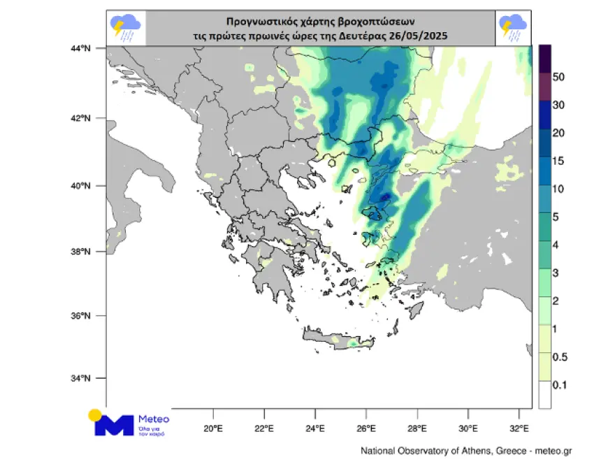
EMY Weather Forecast: Today (Monday)
Eastern Macedonia, Thrace, Northeastern Aegean Islands:
Expect rain and scattered, locally strong storms early in the morning, with quick improvement.
Rest of the Country:
Generally clear skies, except for some local rain in the eastern Aegean and Dodecanese early, and northern Crete by noon.
Winds:
North to northwest at 4–6 Beaufort, locally up to 7 in the Ionian early in the day.
Temperatures:
Lower across the country, reaching 22–24°C in the north and 24–26°C elsewhere.
Regional Forecasts
Macedonia, Thrace:
Cloudy in the east with rain/storms, quickly improving.
Winds: NW 3–5 Beaufort, locally 6 in central Macedonia.
Temperature: 11–24°C (2–3°C lower in western Macedonia).
Ionian Islands, Epirus, Western Greece, Western Peloponnese:
Mostly clear weather.
Winds: NW 5–6 Beaufort, locally 7 in the Ionian early.
Temperature: 14–26°C (lower in inland Epirus).
Eastern Greece, Evia, Eastern Peloponnese:
Mostly clear.
Winds: N 3–5 Beaufort.
Temperature: 15–26°C.
Cyclades, Crete:
Clear skies in the Cyclades, with local clouds in Crete and northern rain by noon.
Winds: N 3–5 Beaufort, locally 6 in the Cyclades early.
Temperature: 15–25°C.
Eastern Aegean Islands, Dodecanese:
Clouds with localized storms early in the northeast, improving quickly.
Further south: local rain early, then clear.
Winds: NW 4–5, locally 6 Beaufort.
Temperature: 18–25°C (cooler in the north).
Thessaly:
Mostly clear weather.
Winds: NW 3–5 Beaufort, locally 6 in the Sporades early.
Temperature: 12–26°C.
Weather in Athens and Thessaloniki
Athens:
Clear skies. Winds: variable 3–4 Beaufort. Temp: 16–26°C.
Thessaloniki:
Clear. Winds: NW 4–5 Beaufort, locally 6 in Thermaikos early. Temp: 12–22°C.
Upcoming Forecasts:
Tuesday, May 27, 2025
Partly cloudy, with more clouds developing in the afternoon over the mainland and mountains, bringing local rain and isolated storms in the north.
Winds: W/NW 3–5, up to 6 Beaufort in the south.
Temperature: slight rise to 26–28°C in the east, 24–26°C elsewhere.
Wednesday, May 28, 2025
Few clouds, increasing in the afternoon over mainland and mountainous Crete, leading to scattered showers/storms.
Winds: NW 3–5, up to 6 Beaufort in the south.
Temperature: no significant change.
Thursday, May 29, 2025
Increased cloud cover in Eastern Macedonia/Thrace in the morning; clouds will thicken from noon in the mainland, Crete mountains, and Ionian. Expect local rain and storms, expanding to the Cyclades and Sporades in the evening.
Winds: NW 3–5 Beaufort.
Temperature: no significant change.
Friday, May 30, 2025
Clouds and storms in the east, easing by evening in most areas except Crete and Dodecanese. Other regions may see local rain and isolated storms over mountainous areas.
Winds: N/NW 3–5, locally 6 Beaufort in the Ionian.
Temperature: slight drop.
Ask Me Anything
Explore Related Questions


